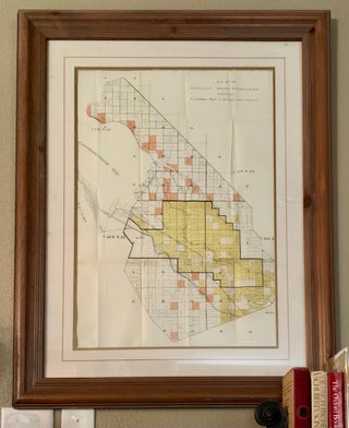
Map of the Puyallup Indian Reservation, Washington, To accompany Report of the Puyallup Indian Commission
[Washington]: [Government Printing Office], 1892. Color Map, 71x53cm, unfolded, set behind glass in a wood frame. Includes creeks, railroads, township range, and parts of Commencement Bay and Tacoma. Divided into sections with ownership and acreages of plots listed. Not inspected out of frame. Tape repairs visible to one horizontal fold.....


![Item #5856 Chester Thorne: 1863-1927 [Cover Title]. The National Bank of Tacoma](https://perusethestacks.cdn.bibliopolis.com/pictures/5856.png?width=320&height=427&fit=bounds&auto=webp&v=1694300048)
